marinezoom.inc@gmail.com
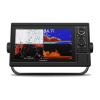
Garmin GPSMAP® 1042xsv 10-inch 10-inch Chartplotter/Sonar Combo Is All-in-1 Solution with Garmin Navionics+ coastal and inland water charts for the U.S. and Canada and GT52-TM transducer
Model: 010-01740-60
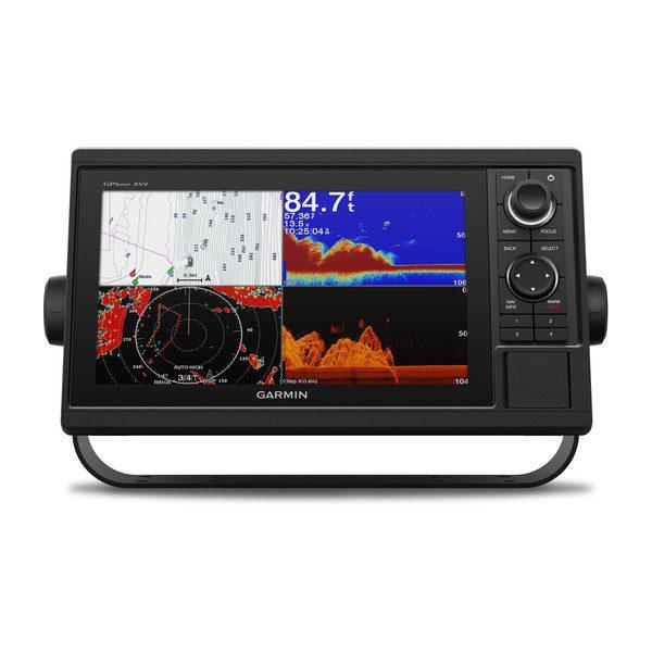
Large, bright 10" screen with keypad interface and multifunction control knob
Includes GT52-TM transducer for Garmin CHIRP sonar and CHIRP ClearVü™ and CHIRP SideVü™ scanning sonars
Supports Panoptix™ and LiveScope™ sonar products (transducers sold separately)
Preloaded Garmin Navionics+™ coastal charts and inland mapping feature Auto Guidance+™ technology Auto Guidance+ is for planning purposes only and does not replace safe navigation operations; plus, there’s support for optional Garmin Navionics Vision+™ premium map content.
Built-in wireless capabilities for Garmin mobile apps
See RPMs, fuel flow, temperature, trim and more for up to four compatible Mercury® engines by using the SmartCraft® Connect gateway
Supports the Garmin Marine Network; allows sharing of sonar, radar, maps, user data, and NMEA 2000® and NMEA 0183 network connectivity support, including autopilots, digital switching, weather, media, VHF, AIS and other sensors
Includes Quickdraw Contours map drawing software
Built-in Garmin SailAssist™ features include laylines, race features, set and drift, wind data and more
Integrated ANT® connectivity support for use with compatible quatix® smartwatches, the gWind™ Wireless 2 transducer, GNX™ Wind marine instrument and remote controls (sold separately)
Experience an advanced all-in-one solution with our 10" GPSMAP® 1042xsv keyed combo. It features a large, bright screen coupled with a keypad interface and multifunction control knob. A GT52-TM transducer is included for Garmin CHIRP sonar along with CHIRP ClearVü™ and CHIRP SideVü™ scanning sonars. There’s also support for Panoptix™ and LiveScope™ sonar products and a wide range of other transducers (sold separately). Preloaded Garmin Navionics+™ coastal charts and inland mapping feature Auto Guidance+™ technology (Auto Guidance+ is for planning purposes only and does not replace safe navigation operations). Plus, there’s support for optional Garmin Navionics Vision+™ premium map content. The combo also includes Quickdraw Contours software and the Quickdraw Community on our Garmin Connect™ online network. Use built-in Wi-Fi® technology to pair with the free ActiveCaptain® smartphone app for access to the OneChart™ feature, smart notifications, Garmin Quickdraw™ Community data and more. Garmin Marine Network support allows sharing of sonar, maps, user data, radar, IP cameras and live sonar among multiple units. Plus, there’s NMEA 2000® and NMEA 0183 network connectivity support, including autopilots, digital switching, weather, media, VHF, AIS and other sensors. These units also include integrated ANT® connectivity support for use with compatible quatix® smartwatches, the gWind™ Wireless 2 transducer, GNX™ Wind marine instrument and remote controls (sold separately). See RPMs, fuel flow, temperature, trim and more for up to four compatible Mercury® engines by using the SmartCraft® Connect gateway.
Specifications
Performance and Physical
Dimensions 12.5″ x 7.3″ x 2.7″ (318 x 185 x 69 cm)
Display size 8.8″ x 4.9″ (224 x 125 cm)
Display resolution 1024 x 600
Display type WSVGA display
Weight 4.1lbs
Water rating IPX7
Antenna Internal or external over NMEA 2000
NMEA 2000® compatible Yes
NMEA 0183 compatible Yes
SiriusXM™ Weather & Radio compatible Yes
Power consumption Max power usage at 10 Vdc: 32.4 W
Typical current draw at 12 Vdc: 1.9 A
Max current draw at 12 Vdc: 2.7 A
Mounting options Bail or flush
Maps and Memory
Preloaded maps Garmin Navionics+ coastal and inland water charts for the U.S. and Canada
Accepts data card 2 SD™ cards
Waypoints 5,000
Routes 100
Track log 50,000 points; 50 saved tracks
Chartplotter Features
Garmin Radar compatible Yes
Garmin Sonar compatible Yes (with external black box, sold separately)
Garmin SmartMode compatible (customizable monitor presets) Yes
Supports AIS (tracks target ships position) Yes
Supports DSC (displays position data from DSC-capable VHF radio) Yes
Tide tables Yes
Garmin Meteor Audio System compatible Yes
Supports Fusion Lync compatible marine radios Yes
GSD™ Black Box sonar support Yes
GCV™ Black Box sonar support Yes
BlueChart® Mobile (planning) compatible Yes
Garmin Helm compatible Yes
GRID™ (Garmin Remote Input Device) compatible Yes
Wireless remote compatible Yes
Connections
NMEA 0183 input ports 1
NMEA 0183 output ports 1
Video input ports 1 BNC
Video output ports None
Wireless connectivity Yes
Garmin Marine Network™ ports 2
Sonar Features and Specifications
CHIRP sonar technology Yes (Built-in)
ClearVü Yes with CHIRP (built-in)
SideVü Yes with CHIRP (built-in)
Dual-frequency (50/200 kHz) sonar capable Yes
Dual-beam (77/200 kHz) sonar capable Yes
Frequencies supported Traditional: 50/77/83/200 kHz
CHIRP (low, medium, high)
ClearVü/SideVü (260/455/800 kHz)
(dependent on transducer)
Transmit power 1 kW traditional; 1 kW CHIRP
Maximum depth 5,000 ft at 1kW (depth capacity is dependent on water bottom type and other water conditions)
Bottom lock (shows return from the bottom up) Yes
Water temperature log and graph Yes
Sonar recording Yes
Sonar history rewind Yes
Transducer port 12-pin
What’s in the Box:
GPSMAP 1042xsv chartplotter Garmin Navionics+ coastal and inland water charts for the U.S. and Canada
Power/data cable
NMEA 2000 T-connector
NMEA 2000 drop cable (2 m)
Bail mount kit with knobs
Flush mount kit with gasket
Protective cover
Trim piece snap covers
Documentation
GT52-TM transducer